Wednesday, Apr 22, 2026
English News
  • Hyderabad
  • Telangana
  • AP News
  • India
  • World
  • Entertainment
  • Sport
  • Science and Tech
  • Business
  • Rewind
  • ...
    • NRI
    • View Point
    • cartoon
    • My Space
    • Education Today
    • Reviews
    • Property
    • Lifestyle
E-Paper
  • NRI
  • View Point
  • cartoon
  • My Space
  • Reviews
  • Education Today
  • Property
  • Lifestyle
Home | India | Isro Report Shows Entire Joshimath May Sink

ISRO report shows entire Joshimath may sink

The pictures are taken from the Cartosat-2S satellite.

By IANS
Updated On - 13 January 2023, 04:14 PM
ISRO report shows entire Joshimath may sink
Photo: ISRO
whatsapp facebook twitter telegram

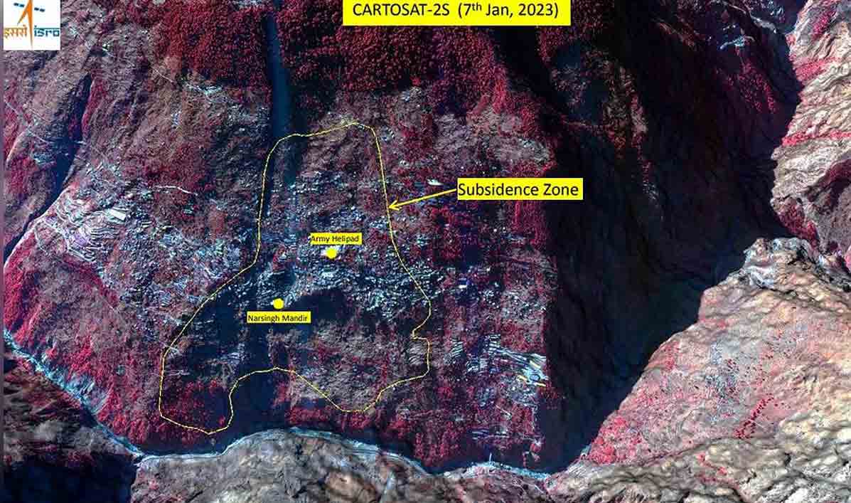
Dehradun: The National Remote Sensing Centre (NRSC) of the Indian Space Research Organisation (ISRO) has released satellite images of Joshimath and a preliminary report on land subsidence which shows that the entire town may sink.

The pictures are taken from the Cartosat-2S satellite.

Also Read

  • Joshimath subsidence: Buildings marked unsafe to be demolished scientifically, says Chamoli DM
  • One more body recovered from Uttarakhand’s Tapovan tunnel; toll rises to 78
  • Uttarakhand: Atmosphere in Tapovan village grim as families lose hope

Hyderabad-based NRSC has released the satellite images of areas that are sinking.

In images, the entire town, including the Army’s helipad and the Narasimha temple, has been marked as sensitive zone.

On the basis of ISRO’s preliminary report, Uttarakhand government is conducting rescue operation in danger-prone areas and the people in these areas are being shifted to safer places on priority.

According to the report, the land subsidence was slow between April and November 2022, during which Joshimath had sunk by 8.9 cm. But between December 27, 2022 and January 8, 2023, the intensity of land subsidence increased and the town sank by 5.4 cm in these 12 days.

The satellite images show that the Joshimath-Auli road is also going to collapse due to the land subsidence.

Although scientists are still studying the cracks that appeared in the houses and roads after the land subsidence in the town, the findings in the primary report of ISRO are frightening.

  • Follow Us :
  • Tags
  • ISRO
  • National Remote Sensing Centre
  • Uttarakhand

Related News

  • Char Dham Yatra 2026: Why pilgrimage begins from Yamunotri

    Char Dham Yatra 2026: Why pilgrimage begins from Yamunotri

  • Char Dham Yatra begins as portals of Gangotri, Yamunotri temples open 

    Char Dham Yatra begins as portals of Gangotri, Yamunotri temples open 

  • G20 satellite expected to be launched in 2027: ISRO chief Narayanan

    G20 satellite expected to be launched in 2027: ISRO chief Narayanan

  • 14-year-old delivers baby boy in Uttarakhand; POCSO case booked against accused

    14-year-old delivers baby boy in Uttarakhand; POCSO case booked against accused

Latest News

  • Trump urges Iran to free right women before Islamabad talks

    2 mins ago
  • Jannik Sinner eyes strong run in Madrid before French Open

    3 mins ago
  • India wins gold, silver and bronze at ISSF Junior World Cup

    5 mins ago
  • Rajasthan Royals eye recovery against Lucknow Super Giants

    8 mins ago
  • Telangana High Court posts BrahMos DG appointment case to June 15

    11 mins ago
  • Falaknuma FC thrash Susai FC 8-0 in TFA C-Division league

    13 mins ago
  • Telangana footballer Alekhya to represent Pune club in Indian Women’s League finals

    16 mins ago
  • Women and students brace for hardships amid RTC strike

    18 mins ago

company

  • Home
  • About Us
  • Contact Us
  • Privacy Policy

business

  • Subscribe

telangana today

  • Telangana
  • Hyderabad
  • Latest News
  • Entertainment
  • World
  • Andhra Pradesh
  • Science & Tech
  • Sport

follow us

  • Telangana Today Telangana Today
Telangana Today Telangana Today

© Copyrights 2024 TELANGANA PUBLICATIONS PVT. LTD. All rights reserved. Powered by Veegam

.