Leonardo da Vinci turned mapping into science
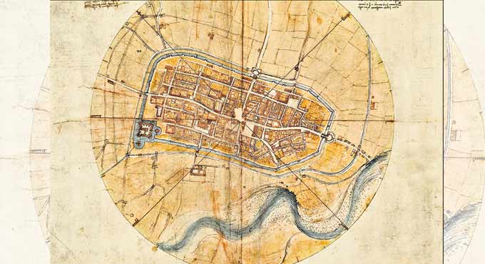
Leonardo created a beautiful and practical map of Imola accurate enough to navigate the Italian city today. The 'Imola Plan' is preserved today in the Leonardiano Museum in Vinci, Italy, the artist’s hometown.
Hyderabad: In 16th century, Leonardo da Vinci returned to Florence from Italy. By that time, Leonardo was already famed for his scientific and artistic achievements, including the design of an innovative catapult around 1485 and the fresco The Last Supper (1495-98).
Cesare Borgia, the son of Pope Alexander VI, became Leonardo’s patron in 1502. Thge artist was told to create a map of the Imola city, near Bologna, which Borgia had seized in 1499. Heavily fortified, it was a key conquest for the young commander. Controlling the city would require understanding its geography and landmarks, and Borgia wanted the map from Leonardo in order to do that.
In the 16th century city maps tended to be symbolic in which religious building got much preferrence. Leonardo’s “Imola Plan” broke with this tradition, aiming to reflect the reality on the ground, and to provide a map that was of more practical use.
Leonardo applied a mapping technique developed by Florentine’s Leon Battista Alberti, who proposed that a town can be mapped using polar coordinates. Starting with Alberti’s technique, Leonardo adapted it to capture more accurate distances, proportions, and relationships between features.
The city’s piazza was fixed in the middle of the grid, and the eight principal directions of the compass radiated out from it. Historians believe that Leonardo collected data on the ground by starting at this central point and then using a compass and odometer to measure streets and landmarks. Using geometry, he could then fill in the rest of the map.
Leonardo’s techniques rendered the first map that used data to accurately show a flattened city as it might be seen from above, what cartographers today call an ichnographic map, perhaps the most familiar type of map used today.
Five centuries later, according to historians, the Imola map can still be used to navigate the city.
Now you can get handpicked stories from Telangana Today on Telegram everyday. Click the link to subscribe.
Click to follow Telangana Today Facebook page and Twitter .