Rewind: Climate-proofing Hyderabad
By Dr Ramesh Chenamaneni In recent years, the India Meteorological Department (IMD) has been issuing long-range rainfall forecasts for four divisions, namely: North Eastern India, Central India, North Western India and Peninsular India. Given the large spatial variation of rainfall and soils within these divisions, farmers in different sub-regions are unable to utilise these higher […]

By Dr Ramesh Chenamaneni
In recent years, the India Meteorological Department (IMD) has been issuing long-range rainfall forecasts for four divisions, namely: North Eastern India, Central India, North Western India and Peninsular India. Given the large spatial variation of rainfall and soils within these divisions, farmers in different sub-regions are unable to utilise these higher scale predictions for cropping decisions to adapt to climate variability.
Moreover, the capacity of the agricultural extension system to create and disseminate location-specific climate forecast-based advisories is at best sub-optimal. Therefore, there is a need to invigorate the current system and bridge the gap in the timely flow of knowledge information based on climate forecast to support the decisions of stakeholders along the agri-food value chain to mitigate climate impacts on agriculture.
For Hyderabad, a comprehensive assessment of the future impacts of climate change is missing, an obstacle to an efficient urban planning process. This article discusses critical issues related to climate change, scientific predictions for the Deccan region as well as challenges for policymakers, planners and administrators. It also proposes specific recommendations for a climate-proof Hyderabad region.
Monsoon Prediction over Northern Telangana
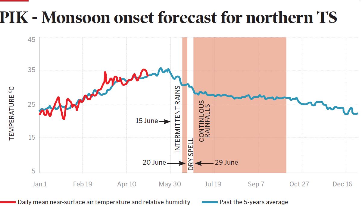
According to the Potsdam Institute for Climate Impact Research in Germany, the Indian Summer Monsoon (the Southwest Monsoon) is likely to reach Northern Telangana on June 15. Intermittent rains may appear during June 14-20. With high probability, a dry spell occurs between June 20 and 29. Continuous monsoon rainfalls are expected after June 29. The uncertainty of the dates is +/- 4 days. (see figure)
Predictions for Hyderabad Deccan Region
The Indo-German Project on Sustainable Hyderabad, led by this author, in which 60 scientists worked for 8 years on different subjects — taking the analysis of 100 years of rainfall and other data at Begumpet — could make for the first time very clear long-term climate change projections and their implications for the city and the Deccan region of Telangana.
Climate change is widely conceived as a global problem where solutions are drawn at a global scale, but it is the multitude of actors within nations who act upon various mitigation strategies
Climate change projections depend on global CO2-emission scenarios, best described by a high (A2, business as usual) and low (B1, global emission reduction from about 2035 on) global emission future. The level of certainty of our climate system representations for Hyderabad was assessed by their degree of consensus with 17 independent climate models (provided by the Intergovernmental Panel on Climate Change). The two most relevant climate variables impacting urban functions are explained:
Very strong monsoon rain events: More than 80mm/day, currently occurring once in two years are the major cause for flooding in Hyderabad, resulting in a wide range of secondary impacts: ranging from adverse health effects to traffic breakdowns and infrastructure damage. Independent of the emission scenario, we have to prepare for a 60% increase in the frequency of these events until 2050. Here, the 17 models show a high agreement under the A2 (business as usual) scenario, while under the B1 scenario, the variance is larger, indicating, however, a definite increase in monsoon events.
Extremely hot days: Currently 1.2 days/year in Hyderabad, according to the IMD definition. They cause direct adverse health effects and a multitude of indirect impacts (accidents, labour slackening etc). In general, there will be a monotonic increase in the frequency of heatwave days during the coming decades, which will certainly be lower for the B1 scenario than for the A2. Compared with the average of days now, for the high-emission scenario (A2), we expect about 20 days until 2050 and 40 in 2100. While for the low-emission scenario (B1) the number with values of 8 and 13 days respectively are still a big challenge.
Higher Temperatures the Norm?
According to studies, it seems that we have to live with rising temperatures in the future. Even if the global warming process will come down in the coming 50 years, we cannot escape from the damage already done to the ozone layer. This means we have to design policies, programmes and implement a range of activities if we are serious about this challenge. The strategy should logically be two-fold:
• In the long-term, we have to see that we bring our environment back again to the track and not sacrifice it for economic growth. This is simply because at a certain stage, the economic growth itself will stagnate as the environment and the resources we derive from it are exhausted.
• In the short- and medium-term, we have to urgently implement climate change adaptation measures in our economic, environmental and social activities so that we can minimise the already disturbing effects of climate change, for example, the present severe heatwaves.
Geography can also increase a community’s vulnerability to heatwaves. In cities, buildings, pavement and dark roofs tend to absorb more heat during the day and retain more heat during the night than does the surrounding countryside—referred to as the ‘urban heat island effect’— which can compound the intensity of high temperatures for city dwellers.
Hyderabad is characterised by extreme climatic conditions – large variations in temperature and precipitation during different seasons
Sustainable Surroundings
Climate change is widely conceived as a global problem where solutions are drawn at a global scale governed by representatives of national governments signing and ratifying sets of rules governing the global climate. But it is the multitude of actors at various levels within these nations who decide or/and act upon various adaptation and mitigation strategies for climate change. Therefore, starting from the cities, towns and villages, communities have to take the responsibility for the implementation of their own local climate change strategies.
Hyderabad as a megacity with about a crore population is characterised by extreme climatic conditions — large variations in temperature and precipitation during different seasons. Climate change calculations for the city performed within the ‘Sustainable Hyderabad’ project show that these conditions are very likely to become more extreme in the future. The city is already hardly able to cope with these extremes, and climate change will increase the frequency and amplitude of further damage-inducing conditions for the people.
A comprehensive assessment of the future impacts can be performed by taking the following steps:
• Identifying properties and certainty ranges of future climate change
• Estimating the consequences of climate change on urban population
• Visualising the social and demographic appearance of the city under climate change conditions
• Identifying and prioritising suitable adaptation steps
Tasks Cut Out
For Government
• Include and consider the climate change predictions for Hyderabad in the Development Master Plan 2031 for the Hyderabad metropolitan region and their impacts on various functions of the city
• Check the decisions of planning and development against their compatibility with future climate change scenarios
• Avoid development in flood-prone areas and/or create adequate drainage infrastructure
• Settlement planning must take into account the likely increase in heatwaves by creating ventilation corridors and shading
• Buildings should be prepared with insulation and passive cooling measures (How about constructing modern houses with old, ancient building architecture as in villages)
• Adapt informal settlements to the effects of climate change
• Traffic planning has to consider increasing flood frequencies in unproblematic locations and should also rely on the spatially explicit CATHY (Climate Assessment Tool for Hyderabad) results. Similarly for road and track planning
For Civil Society
• Engage actively in assessing and debating the development plans of Hyderabad against the backdrop of climate change
• Capacities of Resident Welfare Associations and other NGOs need to be built so that they can tap the development of the newly developed knowledge platform CATHY and also contribute to the enrichment of the tool by adding data on different socio-economic dimensions.
(The author is MLA, Chairman, Indo-German Climate Change Project, and Humboldt Expert in Agriculture, Environment and Cooperation)
CATHY
The Climate Assessment Tool for Hyderabad or CATHY enables planners to deal with complex circumstances. It is a software tool (based on web-GIS) enabling planners to analyse spatially and temporal explicit climate change impacts for different combinations of scenarios in an interactive manner.
Climate variables which are relevant to the urban functioning of Hyderabad can be projected with a good deal of certainty. Spatially explicit projections of climate change impacts, such as heatwave impacts and high precipitations, are possible and can be considered in spatial planning so as to implement relevant recommendations.
The results of this kind of assessment then need to be made available for the planning processes which encompass a wide variety of institutional actors namely, the administrative and planning authority of the metropolitan region, elected council of the corporations and municipalities in the region, other elected governance units, researchers, industries, NGOs and other associations in the civil society.
Now you can get handpicked stories from Telangana Today on Telegram everyday. Click the link to subscribe.
Click to follow Telangana Today Facebook page and Twitter .