Opinion: Saraswati isn’t a mystery
The river had abundant flow but due to tectonic and seismic upheavals, it fragmented and became waterless
Early civilisations like Mohenjo-Daro and Lothal flourished on the banks of river Saraswati. In recent years, scientists have come out with comprehensive studies on geomorphological, sedimentological, geochronological, hydrological and remote sensing aspects of the River Saraswati. A majority of scientists are of the opinion that it was a large river that had abundant discharge and brought a voluminous quantity of sediments.
Moreover, a growing number of scientists and archaeologists believe that the Ghaggar does represent the Saraswati River of yore. The Ghaggar of Haryana is known as Hakra, in Cholistan, and the Nara, in Sindh (both in eastern Pakistan). The great width of the channel, coupled with fluvial (fine particles of rock fragments in a stream of water) thickness of as much as 30-50 m implies that it once carried voluminous discharge of water. That mighty river is now reduced to the Ghaggar-Hakra-Nara river, in which only floodwater flows.
The drainage of the two rivers that once constituted the two branches of the legendary Saraswati encompassed three radically different physiographic-geological provinces. One of the branches, Sutlej (earlier called Shatadru), arose in southern Tibet beyond the Himalaya, the Tons (earlier called Tamasa) emerges in the ever-snowy Himadri or Great Himalayan domain, and the third Chautang (Drishadwati) drained the southern foothill belt of the western Indo-Gangetic plains. In its middle reaches, the river traversed a large swathe of alluvial plain and then passed through the dreary landscape of sand dunes of the Thar Desert before ending in the Rann of Kutch — a delta of Hakra and once a part of the realm of the Arabian Sea.
Scientists have observed that the vast expanse of land traversed by the Saraswati and its tributaries more than once experienced tectonic convulsions and were also severely shaken by earthquakes of large magnitude, resulting in ground displacement. Some parts of it rose while others sank. This indeed happened to the Saraswati and its branches that followed a path riddled with active faults.
The tectonic upheaval, entailing fissuring, sinking and uplifting of the land through which the eastern branch of the Saraswati (Tamasa) flowed, brought a dramatic change in the drainage. As the tectonically resurgent the Aravalli Orogenic belt slowly rose up, the Saraswati and its tributaries shifted progressively westward. With the displaced block impeding its flow, the Tamasa found crushed and the weakened rock of fault zone cut and formed a new channel.
Triveni at Prayag
Flowing southwestward, the Tamasa joined the Drishadwati River, flowing to the upland of Haryana. The Drishadwati thus became a major river. Sometime later, land in the foothills to the east of Paonta Sahib Fault (Yamuna Tear) sank. This sinking forced the then south-westward flowing river to deflect southward towards the then Yamuna, which was a tributary of Chambal – a tributary of the Ganga. The Tamasa now joined the Yamuna, which became its carrier and delivered the Tamasa to the Ganga at Prayag — a confluence of Ganga and Yamuna. The Saraswati joined through its channel of the Yamuna, and it became Triveni.
The Winter Westerlies — the strongest wind in the winter blowing from west to east — continued to provide precipitation and piled up snows in the mountainous catchment of the two branches of the Saraswati. The meltwater sustained the flow of the Saraswati river in the Harappan period. The Harappans left their abode when the river lost all its water due to the capture of its eastern branch by the Yamuna and of its western branch by the Vipasa (Beas) river, depriving the Saraswati of its water discharge.
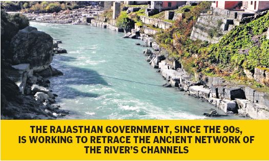
Mystery Solved
Now with the aid of remote sensing through orbiting satellites, the mystery of the river is almost solved. The Rajasthan government, since the 90s, is working to retrace the ancient network of the channels. The Rajasthan Ground Water Department (RGWD) is assisted by the Central Ground Water Board (CGWB), Indian Space Research Organization (ISRO), Bhabha Atomic Research Center (BARC) and National Physical Laboratory, Ahmedabad.
The RGWD is investigating the site of channels while CGWB is carrying out drilling activities for water and soil samples by carbon dating. The team is of the opinion that the Saraswati entered Rajasthan in Ganganagar district and tail ends in Bikaner and Jaisalmer districts near the Rann of Kutch. Studies reveal that there are big paleochannels, 60-70 m underground, and water was moving slowly towards the sea. The presence of alluvial sediment points to the existence of freshwater flow source along palaeochannels, which are present in all the 10 districts of western Rajasthan and pertain to the Saraswati river.
In Mythology
Mythologically, the Saraswati was a highly venerated river in the times it watered the vast expanse of the land known as Saptasindhav — the land of seven rivers — Saraswati, Sutlej (Satadru), Beas (Vipasa), Chenab (Asikani), Ravi (Parushni), Jhelum (Vitasta) and Sindhu (lndus) — (Rigveda 8.24.27). The Rigveda describes Saraswati as ‘naditama’, the best of all rivers (R 2.41.16), surpassing all other rivers in splendour and benevolence — ‘mahimana mahinar’ (R 6.61.13).
It was a mighty river — ‘maho arnah’ (R 1.3.12) — abounding in water that was pure in the source of mountains to the sea — ‘shuchiryati giribhya a’ — samudrat (R 7.95.2). It was the most impetuous of all rivers — ‘apasam apastama’ (R 6.61 13) — that descended with roar ‘charati roruvat’ down the slope, its fierce current gurgling (R 6.61.7) through its canyon course and was the mother of rivers (Sindhumata).
In Skand Puran, the Saraswati is shown as originating in the snowy Himalayas and flowing down to the foothills. On its way down to the plains, the river cut through mountain ranges, after watering the Kurukshetra region, turned westward and flowed through forests such as Sitavan ‘Aditivan’ and ‘Dvaitvan’.
Further downstream, the Pandavas during their exile and later Balram, Krishna’s brother, noticed that at a place, Vinashan, the river disappeared under the mass of sands (Mahabharata Van Parv 25.1). Balram had started his journey from the place where the river met the sea ‘samudrum pashchimum gatva sarswatyabdhisangamam’ (Mahabharata Shalya Parv 35.77). This makes it clear that as per Rigveda, the Saraswati originated in the Himalayas and as per Mahabharata, it degenerated into middle reaches and went under a pile of sands in the lower reaches. In the sand desert, the Saraswati became subterranean, an underground (‘antahsalila’) river.
The Rigveda, Purans and the Mahabharata transmit across a time span of about 3,000 years remarkably accurate descriptions of the great river. Evidence shows that the river was not a mystery. It had abundant discharge and was the most venerated. But subsequently, due to tectonic and seismic upheaval, it fragmented and became waterless.
(The author is a retired IFS officer)
Now you can get handpicked stories from Telangana Today on Telegram everyday. Click the link to subscribe.
Click to follow Telangana Today Facebook page and Twitter .