Lines of conflict
In fragile Northeast abound with border disputes, the flare-up between Assam and Mizoram over territorial claims is risky

With inputs from Agencies
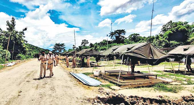
Police deployed at Lalilapur police patrol post in Cachar district bordering Mizoram following the inter-State border clash on July 26. — Photo: ANI
A bloody clash on July 26 between Assam and its neighbour Mizoram has put the focus again on the inter-State border conflict in the Northeast. At least six persons were killed and 60 others, including an SP, were injured in the violence.
Himanta Biswa Sarma, Chief minister of Assam, told reporters on July 27 that not only was Mizoram constructing a road inside the inner line reserve forest on the Assam border near Lailapur, a new armed outpost of the Mizoram Police had also come up. On the other side, Lalchamliana, Mizoram Home Minister, said that Mizoram policemen responded “spontaneously by firing back” at Assam police officials after they “forcibly crossed” a Central Reserve Police Force post.
Interestingly, just a week before Union Home Minister Amit Shah had held a conference with the Chief Ministers of northeastern States to resolve prickly border disputes. The BJP is in power in Assam, while the Mizo National Front, a constituent of the BJP-led North East Democratic Alliance, is ruling Mizoram. Both the Chief Ministers had attended the meeting in Shillong, but it seems to have had little impact.
While Mizoram accused Assam of encroaching upon its land and forcibly seized the Aitlang area about 5 km west of Vairengte village in its Kolasib district, Assam accused Mizoram of building structures and planting betel nut and banana saplings allegedly 10 km inside Hailakandi district.
Assam and Mizoram have differing interpretations of their territorial border. Mizoram believes that its border lies along an inner line drawn up in 1875 to protect tribals from the influence of plainsmen while Assam goes by a district demarcation survey done in the 1930s.
Perception Vs Reality
Cartographers’ lines drawn on survey maps pitted against local people’s perception of traditional boundaries are at the root of border disputes between Assam and States that were carved out of it post-Independence.
As long as these States remained part of Assam, these perceptions and lack of details in the cartographic maps did not matter, as a tribe’s claims on the other side of a district’s border were not challenged by any authority. However, as these became inter-State borders with excise and police posts, land ownership on either side of the imaginary line became a hotly contested issue.
Almost all northeastern States, barring the former princely States of Tripura and Manipur, were carved out of Assam in the decades following India’s independence in 1947. District borders drawn by cartographers on a 1 cm: 1 km scale became inter-State borders for what were till then hilly and remote districts of a huge State.
“Sometimes the lines were drawn across a hill, sometimes through a forest on maps which did not clarify whether the hill slope or forest patch through which the line went was Assam’s or its new neighbouring State’s. On the ground, it meant a lot of headache for administrators as the line often also clashed with a tribe’s perception of its traditional hunting or grazing or jhum (shifting) cultivation lands,” points out Ranjan Chatterjee, former chief secretary of Meghalaya, who served Assam for much of his career.
PH Hauzel, former chief secretary of Mizoram, said land in the Lushai Hills, which is what Mizoram was called before 1972, when it became a separate Union Territory, was controlled for centuries by chieftains and the areas which form the current conflict zone were the hunting grounds of some of these chiefs. An inner line drawn up by the British for these tribal areas in 1875 to protect tribes from influences of plainsmen seemingly sanctified these tribal claims. “When district boundaries were later drawn up by the British in the 1930s, some of these traditional tribal land appeared on the other side of the boundary….this was perhaps done as tea gardens were encroaching on these forests,” he points out.
With populations in all States spilling over, and land in a once scarcely populated part of India turning into a prized possession, the issue started acquiring economic underpinnings.
Nagas who were the first to get a State of their own in 1963, have been among the most aggressive in demanding redrawing of maps so that all areas where they live, regardless of the State where the land is located, are part of Nagaland. “Assam wants status quo….the tribal States which were carved out of it do not agree. Each tribe has its own historical narrative on land ownership, these are often at variance with the official map or another tribe’s or a plains community’s narrative,” says Chatterjee.
Claims and Conflicts
Though disputes and clashes started within years of the new States coming into being, the first major conflict was in 1985, when a firefight between armed Nagas and Assam police resulted in more than 40 people losing their lives. Assam alleges that Nagas have over the years taken over more than 60,000 hectares of forest land in Sivasagar, Golaghat and Jorhat districts, while Nagaland politicians claim that these were traditional Naga lands and should never have been shown as part of Assam.
Seven years after Nagaland was formed, a separate autonomous State comprising Khasi, Garo and Jaintia hills was carved out within Assam. In 1972, this became a full-fledged State Meghalaya — named by the famous linguist Suniti Chatterjee. In the same year, the North Eastern Frontier Agency, which after 1947 had become part of Assam, was renamed Arunachal Pradesh and made a Union Territory.
A North-East States Reorganisation Act passed by Parliament laid down the boundaries of these States. However, soon after becoming States, both Meghalaya and Arunachal disputed their borders. While Meghalaya disputed the award of part of Mikr Hills which went to Assam, Arunachal claimed that Assam had encroached on its land.
The village of Langpih, which Meghalaya says is Garo land and Assam insists is part of Kamrup district, became a flashpoint as early as 1974. Thirty-six years later, it became the site for a pitched battle between Khasis, Garos and Nepali farmers.
“High-pitched identity politics which is the norm in the Northeast has continued to “compound the boundary problem,” notes Chatterjee. Attempts by successive Central governments to sort out the border conflicts have failed till now.
 Centre Can’t Hold
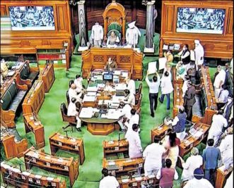
An insight into the Centre’s approach to border row among States can be gauged by what the government told the Lok Sabha last Monday. It said such disputes can “only” be resolved with the cooperation of States involved and the Union government just acts as a facilitator.
“The approach of the Central government has consistently been that inter-State disputes can be resolved only with the cooperation of the State governments concerned and that the Central government acts only as a facilitator for amicable settlement of the dispute in the spirit of mutual understanding,” said Minister of State for Home Nityanand Rai.
 Where’s the Boundary?
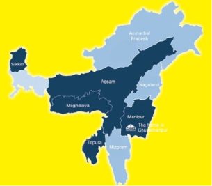
Meghalaya
The problem between Assam and Meghalaya started when the latter challenged the Assam Reorganisation Act of 1971, which gave Blocks I and II of the Mikir Hills or present-day Karbi Anglong district to Assam. Meghalaya contends that both these blocks formed part of the erstwhile United Khasi and Jaintia Hills district when it was notified in 1835. At present, there are 12 points of dispute along the 733-km Assam-Meghalaya border.
Meghalaya bases its case on survey maps of 1872 and 1929 and certain notifications of 1878 and 1951 while Assam wants to go by the recommendations of the Churachand Committee which in turn has been rejected by Meghalaya. Joint surveys of the disputed border segments have been undertaken in part and the Chief Ministers of both the States are scheduled to meet again on August 6 at Guwahati to discuss ways to resolve the dispute.
Arunachal Pradesh
Arunachal’s grievance is that the re-organisation of Northeastern States unilaterally transferred several forested tracts in the plains that had traditionally belonged to hill tribal chiefs and communities to Assam. After Arunachal Pradesh achieved statehood in 1987, a tripartite committee was appointed which recommended that certain territories be transferred from Assam to Arunachal. Assam contested this and the matter is before the Supreme Court.
Mizoram
Following a border incident in 2007, Mizoram declared that it does not accept the present boundary with Assam and that the inner line of the Inner Line Reserve Forest as described in the 1875 notification under the Bengal Eastern Frontier Regulation (BEFR) of 1873 should be the basis for delineating the border and not the 1933 district boundary demarcation, which Assam wants to be enforced.
Nagaland
The longest-running border dispute in the Northeast is between Assam and Nagaland, which began soon after Nagaland became a State in 1963. The Nagaland State Act of 1962 had defined the State’s borders according to a 1925 notification when Naga Hills and Tuensang Area (NHTA) were integrated into a new administrative unit.
Nagaland, however, does not accept the boundary delineation and has demanded that the new State should also have all Naga-dominated areas in North Cachar and Nagaon districts. Since Nagaland did not accept its notified borders, tensions between Assam and Nagaland flared up soon after the latter was formed, resulting in the first border clashes in 1965.
The Assam government had filed a case in the Supreme to resolve the border dispute and for a permanent injunction restraining Nagaland from encroaching areas within the constitutional boundary of Assam. In 2005, the Supreme Court instructed the Central government to constitute a boundary commission to settle various inter-State boundary problems in the Northeast. The Centre had earlier constituted two commissions — Sundaram Commission (1971) and Shastri Commission (1985) — to settle the Assam-Nagaland border dispute. These commissions, however, failed to resolve the matter.
With inputs from PTI, Agencies
Now you can get handpicked stories from Telangana Today on Telegram everyday. Click the link to subscribe.
Click to follow Telangana Today Facebook page and Twitter .