Opinion: Reducing urban flooding
Urban flood modelling simulations assuming high-intensity rainfall patterns in cities can provide insights
Dr Oruganty Prasada Rao
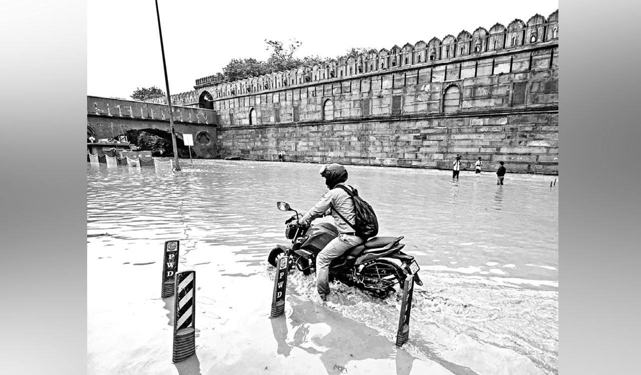
This year, many cities in India have been affected by record urban flooding, including Bengaluru, Hyderabad, Delhi, Gurugram, Rajkot, Jaipur and Mumbai. The Red Fort was submerged due to high floods in the Yamuna River. Its waters reached the walls of the Taj Mahal. In Kota, Rajasthan, people posted videos of crocodiles in residential areas. Worldwide too, many cities were flooded, viz, New York, Vermont, London, Beijing and Auckland.
Also Read
Urban flooding is caused by a combination of natural and anthropogenic (manmade) factors. Further, climate change caused mostly by the burning of excessive fossil fuels by humans has resulted in heavier rainstorms as well as severe and frequent floods that are hard to predict. Durban in South Africa is one example of a city that has been affected by climate change-induced floods.
Flood Peaks, Volumes
Urban flooding is significantly different from rural flooding as urbanisation leads to developed catchments, which increases the flood peaks from 1.8 to 8 times and flood volumes by up to 6 times. Consequently, flooding occurs very quickly due to faster flow times in a matter of minutes (National Disaster Management Authority). Roads turn into canals.
Sea level rise due to global warming is threatening the existence of coastal cities by submergence. This depends on the rate of sea level rise and the measures taken to mitigate it. According to LiveScience, some of the most vulnerable cities include Male, Dhaka, Jakarta, Miami, New York City, New Orleans, Tokyo, Mumbai, Shanghai, Bangkok and Ho Chi Minh City.
The built-up area of Indian cities has been expanding rapidly without correspondingly increasing the capacity of stormwater drains either by renovating existing drains or constructing new ones. New constructions are taking place in low-lying areas due to rising land prices and less availability of land. Structures come up by encroaching upon lakes, wetlands and riverbeds obstructing natural drains. All these human activities leave less ground (previous surface) for water percolation, thereby leading to flooding even for short spells of rain, occurring any time of the year and not just limited to the rainy season.
Shrinking Wetlands
Wetlands reduce the severity of floods and waterlogging by storing it. But, according to reports, the wetlands of Mumbai have reduced with time, while the built-up area has increased, leading to a reduction in storage capacity.
Stormwater drains are channels that carry off rainwater from impervious surfaces such as paved streets, car parks, parking lots, footpaths, sidewalks and roofs. These surfaces increase as the built environment increases leading to flooding. Stormwater drains get choked with silt and garbage which need to be cleaned regularly, especially before the onset of monsoon, otherwise, they don’t discharge rainwater effectively leading to inundation of built-up areas. The drainage system needs to be planned before taking up new constructions, but it is seldom followed.
The flow of water is slowed down by vegetation, which also facilitates its percolation into the ground. The cutting down of trees removes barriers to the flow of water. Also, deforestation quickens the process of soil erosion and silting of river beds, decreasing their carrying capacity and resulting in water flowing over their banks.
Floods are also caused by the haphazard construction of roads and bridges, without proper drainage systems. Importantly, population pressure leads to urban flooding following the increase in impervious areas, thereby resulting in less infiltration of water and greater surface runoff.
Heat Island
‘Urban heat island effect’ is a phenomenon whereby cities experience higher air temperatures than the surrounding countryside. There is a connection between urban heat island effect and urban flooding. The area of the urban heat island has buildings with little vegetation cover, which may be one of the reasons for the local heavy rainstorms.
Floods are responsible for causing extensive damage to the infrastructure, which includes roads, bridges, and electric and water supplies apart from loss of life. The cost of reconstruction is a drain on the economy. The funds, which may have been intended for use in development activity, need to be diverted towards them depriving growth of the area.
Besides, numerous health problems are caused as a result of a lack of sanitation, death of livestock and dirty water. The psychological impact of losing lives and property due to flooding is huge and the recovery process painful.
Mitigation Measures
Controlling climate change by reducing drastically the emission of greenhouse gases, particularly carbon dioxide, ultimately reaching zero emissions needs to be seriously and expeditiously followed.
Nature-based solutions to flooding include rainwater harvesting, green roofs, rain gardens, bioswales, permeable pavement and constructed wetlands. All of them are designed to absorb and retain rainwater. They thus help reduce the amount of water that enters the drainage system and surface water flooding apart from reducing the urban heat island effects. Cities around the world are using nature-based solutions to mitigate flooding. Examples include Melbourne, Portland, Oslo, San Francisco, Singapore and China, according to SpringerLink.
There are ways to reduce the effects of urban heat islands by ensuring abundant tree cover and green space which act as sources of shade and promote evaporative cooling. Other options include the use of lighter-coloured surfaces and less absorptive building materials in urban areas, to reflect more sunlight and absorb less heat.
Urban flood modelling simulations assuming high-intensity rainfall patterns in cities can provide insights into the intensity of floods based on which drainage systems can be evolved. Mitigation measures for urban flooding can be both structural and non-structural. Structural measures include flood walls, embankments and flood warning systems. Non-structural measures comprise better forecasting of rainfall and real-time dissemination of flood warnings.
Sponge cities are urban areas designed to retain rainwater and absorb it where it falls through sustainable drainage systems, abundant trees, lakes and parks to prevent flooding. China has the highest number of sponge cities.
Climate change has disrupted the rainfall pattern. Also, urban heat lands have increased rainfall over urban areas resulting in flooding. The rising sea levels are adding to the problem. Encroachments on drainage areas like lakes, wetlands and riverbeds are causing floods. Pollution of water bodies is reducing their storage capacity.
Saving as much rainwater as possible through rainwater harvesting and underground storage in tanks reduces urban flooding and augments freshwater availability. Regularly cleaning stormwater drains and increasing their capacity matching with the addition of built-up areas are crucial in flood control. Timely forecasts of heavy rains that can lead to flooding and evacuation of people will save lives.

Related News
-

KTR says Congress has lost people’s confidence ahead of Yuva Sangrama Sabha
-
Telangana tops India in cybercrime FIRs despite Rs 1,524 crore fraud losses in 2025
-
KT Rama Rao credits BRS for Amara Raja battery plant in Mahabubnagar
-
Varahi Jewels launches four-day anniversary jewellery exhibition in Hyderabad